Alabama's Magnificent River Systems: A Natural Wonder delves into the profound significance of Alabama's intricate network of river systems. These waterways, including the Tennessee River drainage, Mobile River basin, and coastal drainages, are pivotal to the state's ecological diversity and economic prosperity.
From supporting a rich array of aquatic life to facilitating navigation and power generation, these river systems play a vital role in various sectors. This article explores the classification, geographic features, and unparalleled importance of Alabama's river systems, shedding light on their profound impact on the state's natural heritage and economy.
Key Takeaways
- Alabama's river systems and water resources are of great importance, contributing to the state's economic development and biodiversity.
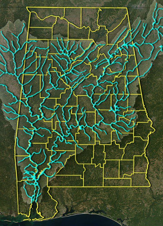
- Alabama can be divided into three main river system areas: the Tennessee River drainage in the north, the Mobile River basin in the central region, and the coastal drainages in the south.
- The Tennessee River drainage covers 13% of Alabama's land area and provides flood control, power generation, navigation, and recreation opportunities.
- The Mobile River basin is the largest in Alabama, draining 63% of the state's land area and consisting of various river systems and impoundments.
The Significance of Alabama's River Systems
The significance of Alabama's river systems cannot be overstated in their contribution to the state's natural beauty and economic development. These river systems play a crucial role in the economic impact of Alabama, providing numerous opportunities for commerce, transportation, and recreation.
Moreover, they are vital to the conservation of the state's rich aquatic and semi-aquatic biodiversity. Alabama's river systems are not only a source of immense natural beauty but also contribute significantly to the state's economy through activities like fishing, boating, and tourism.
It is imperative to recognize the importance of conservation efforts to maintain the ecological balance and sustainability of these river systems, ensuring their continued economic and environmental benefits for the state. Therefore, effective conservation measures are essential to safeguard the economic and ecological significance of Alabama's river systems.
Classification and Geographic Features
Alabama's river systems can be categorized into three distinct regions based on their geographic location and characteristics.
The topography of Alabama allows for the classification of river systems into the Tennessee River drainage in the north, the Mobile River basin in the central region, and the coastal drainages in the south.
The Tennessee River, originating in Virginia, North Carolina, and Tennessee, brings about 14,000 cubic feet per second of stream flow on its journey through Alabama.
The Mobile River basin, draining approximately 32,700 square miles in Alabama, Mississippi, Tennessee, and Georgia, encompasses the upper Tombigbee River, the Black Warrior River, the Alabama River, Cahaba River, Coosa River, and Tallapoosa River systems.
Coastal river drainages include the Escatawpa and Chickasawhay River systems, the Perdido River, the Escambia, Conecuh, Yellow rivers, and the Pea River.
Tennessee River Drainage in Alabama
Located in the northern region of Alabama, the Tennessee River drainage is a significant and vital component of the state's river systems.
- The Tennessee River provides vital flood control, electrical power generation, and navigation, contributing to the economic development of Alabama.
- It adds about 14,000 cubic feet per second of stream flow on its journey through Alabama, supporting agricultural and industrial activities.
- The river also offers abundant recreational opportunities, attracting tourists and boosting the local economy.
- The Tennessee River drainage area, covering approximately 6,800 square miles, plays a crucial role in sustaining the ecological balance and biodiversity of Alabama's northern region.
This river system's economic impact is substantial, enhancing the quality of life for residents and fostering the state's overall prosperity.
Mobile River Basin in Alabama
With its vast drainage area spanning across multiple states, the Mobile River basin in Alabama serves as a crucial component of the state's diverse river systems. This extensive basin, draining approximately 32,700 square miles in Alabama alone, plays a pivotal role in ecosystem conservation and has a significant economic impact.
The basin is home to various sub-basins, including the upper and lower Tombigbee River, the Black Warrior River, the Alabama River, the Cahaba River, the Coosa River, and the Tallapoosa River systems. The impoundments within the basin, such as Lewis Smith Lake and Lake Martin, contribute to both ecological preservation and economic activities.
Moreover, the Mobile-Tensaw Delta, formed by the Mobile River, enriches the region's biodiversity and supports numerous economic activities.
Thus, the Mobile River basin stands as a vital area for ecosystem conservation and a key economic driver in Alabama.
Coastal River Drainages in Alabama
The coastal river drainages in Alabama encompass smaller river basins that ultimately empty into the Gulf of Mexico.
- Biodiversity in Alabama's coastal river drainages
- The coastal river drainages in Alabama are home to a rich variety of flora and fauna, including numerous species of fish, birds, and other wildlife.
- Ecological importance of Alabama's coastal river systems
- Alabama's coastal river systems play a vital role in maintaining the ecological balance of the region, providing habitats for diverse species and contributing to the overall health of the Gulf of Mexico.
- The unique ecosystems within these coastal river drainages support a wide array of plant and animal life.
- The rivers' proximity to the Gulf of Mexico makes them crucial for both local biodiversity and the broader marine ecosystem.
Frequently Asked Questions
What Are the Best Spots for Fishing Along Alabama's River Systems?
The best spots for fishing along Alabama's river systems include Lake Guntersville, Pickwick Lake, and the Mobile-Tensaw Delta. Optimal baits include live worms, crickets, or artificial lures. Effective fishing techniques involve casting near structures or using topwater lures.
How Do Alabama's River Systems Impact the Local Economy and Industries?
Alabama's river systems play a pivotal role in the local economy and industries. They drive economic growth through local tourism, supporting activities like fishing, boating, and water sports. Furthermore, they provide opportunities for industries such as transportation and hydroelectric power generation.
What Are the Potential Threats to the Health and Sustainability of Alabama's River Systems?
Potential threats to Alabama's river systems include pollution from agricultural runoff and industrial waste, habitat destruction from urban development, and the impacts of climate change. These factors pose significant environmental impact risks, threatening the health and sustainability of the state's vital water resources.
Are There Any Ongoing Conservation or Restoration Efforts for Alabama's River Systems?
Conservation efforts and river restoration initiatives in Alabama aim to improve fish populations and water quality. These efforts include habitat restoration, reducing pollution, and implementing sustainable management practices to preserve the state's magnificent river systems.
How Do Alabama's River Systems Contribute to the State's Cultural and Historical Heritage?
Alabama's river systems flow like veins, nurturing the state's cultural heritage and shaping its history. From providing transportation routes for early settlers to serving as a source of inspiration for art and literature, these waterways hold profound cultural significance. Their environmental impact is immeasurable.
Conclusion
In conclusion, Alabama's river systems play a crucial role in the state's natural environment and economy.
Their classification, geographic features, and significance highlight their profound impact on Alabama's heritage and development.
As the saying goes, 'water is the lifeblood of the earth,' and Alabama's magnificent river systems serve as a natural wonder that must be preserved and sustainably managed for the benefit of future generations.
Our Reader’s Queries
How many river systems are in Alabama?
Alabama boasts 17 major river systems that weave through a whopping 132,000 miles of channels. With 1,438 miles of navigable channels, the state takes the lead in this category nationwide.
What are 2 major rivers in Alabama?
1. Tennessee River dominates as the longest river in Alabama, stretching a remarkable 652 miles.
2. The Chattahoochee River follows closely behind, spanning a significant 430 miles in length.
3. Next in line is the Alabama River, covering a distance of 318 miles.
4. The Coosa River also makes the list, measuring in at a substantial 280 miles.
What is the watershed of a river system?
A watershed is a piece of land that directs water into a particular body of water. All bodies of water have a watershed. Rain and melted snow flow through watersheds into streams and rivers. These smaller bodies of water then flow into bigger ones, such as lakes, bays, and oceans.
What body of water runs through Alabama?
As its name suggests, the Alabama River meanders through the core of Alabama. Beginning north of Montgomery, the Alabama River is formed from the merging of the Coosa River and the Tallapoosa River near the Fall Line.
Check Out For More References