'Alabama's Diverse Geology Unveiled: A Geological Wonderland' offers a comprehensive exploration of Alabama's multifaceted geological landscape. From the ancient Precambrian era to the present Holocene period, the state's geological narrative unfolds through a tapestry of diverse landforms and rock formations.
This article meticulously examines the formation of the Gulf of Mexico basin and the prevalence of sedimentary, igneous, and metamorphic rocks, providing valuable insights into the Earth's chronicles. Delving into the distinct physiographic sections of Alabama, it unravels their unique geological epochs and compositions.
Furthermore, the article illuminates the significance of sedimentary rocks in various industries, water resources, and associated hazards, while also highlighting the abundance of fossils and fossil fuels, and their impact on tourism.
A must-read for geology enthusiasts and researchers, this article offers a profound understanding of Alabama's geological marvels.
Key Takeaways
- Alabama has a geologically diverse history spanning from Precambrian to Holocene, with episodes of continental collision and mountain building.
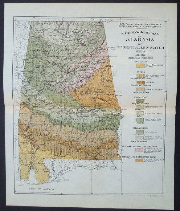
- The state is divided into five physiographic sections: Cumberland Plateau, Highland Rim, Valley and Ridge, Piedmont Upland, and East Gulf Coastal Plain, each characterized by specific geologic age and composition.
- Alabama's bedrock is composed of limestone, sandstone, shale, and chalk, which were formed in ancient oceans, swamps, and near-shore environments.
- The state is rich in fossils, providing insights into ancient organisms and environments, and has significant coal, oil, and natural gas reserves.
Geologic History and Physiographic Sections
Throughout its geologic history spanning from Precambrian to Holocene, Alabama has experienced episodes of continental collision and mountain building, resulting in diverse physiographic sections characterized by specific geologic age and composition.
The state's geologic age classification reveals a rich tapestry of formations and evolutions. From the Cumberland Plateau's Paleozoic sandstone, shale, and limestone to the Highland Rim's predominantly Paleozoic limestone and chert, each physiographic section tells a story of the Earth's ancient processes.
The Valley and Ridge section showcases diverse Paleozoic sedimentary rocks, folded ridges, and valleys, while the Piedmont Upland boasts faulted crystalline metamorphic and igneous rocks.
The Mesozoic and Cenozoic strata of the East Gulf Coastal Plain record the formation and evolution of the Gulf of Mexico basin.
Alabama's geologic history and physiographic sections stand as a testament to the state's rich and varied geological heritage.
Sedimentary Rocks in Alabama
Sedimentary rocks in Alabama were formed over millions of years in ancient oceans, swamps, and near-shore environments. The state's bedrock is composed of limestone, sandstone, shale, and chalk. Limestone formations are particularly significant, with limestone quarrying being the largest nonfuel mineral industry in Alabama. This industry plays a crucial role in producing limestone for cement, agricultural lime, and crushed stone. Furthermore, sedimentary rocks are vital for groundwater reservoirs and agricultural development, with rock types like chalk and marls contributing to the development of fertile soils. These sedimentary formations not only offer insights into the state's geologic history but also have substantial economic significance, making them a cornerstone of Alabama's mineral industry.
| Economic Significance of Sedimentary Rocks | Limestone Quarrying |
|---|---|
| Largest nonfuel mineral industry in Alabama | Vital for cement, agricultural lime, and crushed stone production |
| Essential for groundwater reservoirs and agricultural development | Significant economic contribution to the state |
Igneous and Metamorphic Rocks
Alabama's igneous and metamorphic rocks, ranging in age from Precambrian to Devonian, showcase a diverse array of mineral resources and geological formations. These rocks have been shaped by intricate geologic processes, resulting in a rich tapestry of valuable resources and stunning landscapes.
Key points to note about these rocks include:
- They have yielded metallic and nonmetallic mineral resources such as gold, lead, zinc, mica, and talc.
- The Piedmont Upland has been a source of marble and granite through successful quarrying operations.
- Gemstones like star blue quartz, garnet, and tourmaline have been collected from this region, adding to its mineral wealth.
- These rocks have played a crucial role in providing valuable mineral resources, contributing to various industrial and commercial activities.
- The formation and evolution of these rocks have significantly contributed to the geological diversity and natural beauty of Alabama's landscape.
Fossils and Fossil Fuels
The geological richness of Alabama's igneous and metamorphic rocks extends into its fossil and fossil fuel deposits, providing a valuable window into ancient life and significant energy resources.
Alabama's sedimentary rocks are renowned for their fossil preservation, offering a glimpse into prehistoric organisms such as trilobites, corals, crinoids, and even terrestrial dinosaur bones. Paleontological studies in the state have contributed significantly to our understanding of past environments and life forms.
Furthermore, Alabama ranks 14th in coal production in the US, with three main coal fields, and has also yielded substantial oil and natural gas reserves from geologic strata ranging from the Cambrian to Miocene periods. These fossil fuels play a crucial role in meeting the energy needs of the state and the nation, underscoring the significance of Alabama's diverse geology in both historical and contemporary contexts.
Industries and Water Resources
The state is ranked third in limestone quarrying, a key industry in Alabama, with limestone being utilized for cement, agricultural lime, and crushed stone. This industry has a significant economic impact on the state.
Additionally, sand and gravel production is important, especially in southern Alabama.
Alabama is a major producer of clays, including bentonite, common clay, fireclay, fullers earth, kaolin, and shale.
Water management is crucial, as Alabama has over 132,000 miles of stream channels, and approximately 18% of all surface water in the lower 48 states flows through the state. Groundwater sources provide 40% of public water supplies in Alabama, highlighting the importance of effective water resource management for the state's industries and communities.
Geologic Hazards
Geologic hazards in Alabama, including earthquakes, sinkholes, and landslides, pose significant risks to the state's infrastructure and natural landscapes. The impact of geologic hazards on infrastructure necessitates effective geologic hazard mitigation strategies to safeguard lives and property.
Alabama has experienced multiple earthquakes of moderate intensity, primarily associated with the Southern Appalachian Seismic Zone and the Bahamas Fracture Seismic Zone. Areas underlain by carbonate rocks are particularly susceptible to sinkholes, with the largest sinkhole recorded in Shelby County in 1972.
Landslides can occur on steep, poorly drained slopes, especially in the Cumberland Plateau, Valley and Ridge, and Piedmont Upland regions. To mitigate these hazards, it is crucial to implement comprehensive geologic hazard assessments and develop infrastructure resilience plans to minimize the potential impact on communities and the environment.
Tourism and Recreational Sites
Alabama's diverse geology offers a range of tourism and recreational sites for visitors to explore. These sites showcase natural wonders and provide opportunities for outdoor adventures.
- Cathedral Caverns: Known for its stunning rock formations and one of the largest cave entrances in the world.
- Cheaha State Park: Offers hiking and climbing opportunities with scenic overlooks and canyons carved from metamorphic rocks.
- Bladon Springs and Blount Springs: Tourist attractions for their mineral-rich waters.
- Rickwood Caverns and Majestic Caverns: Popular for caving and karst geology, attracting adventure seekers.
- Alabama's beaches in Mobile and Baldwin Counties: Famous for their white sands, attracting millions of tourists annually for beachcombing and relaxation.
Visitors can immerse themselves in the geological wonders of Alabama while enjoying a variety of outdoor activities.
Frequently Asked Questions
What Are the Specific Types of Gemstones Found in Alabama's Piedmont Upland Region?
The Piedmont Upland region in Alabama yields gemstones like star blue quartz, garnet, and tourmaline. Gemstone mining in this area has an economic impact, contributing to Alabama's mineral industry and attracting interest from both tourists and collectors.
How Does Alabama's Geology Contribute to the State's Ranking as the Third Largest Producer of Limestone in the Nation?
Alabama's ranking as the third largest producer of limestone in the nation is attributed to its diverse geological formations. The state's rich sedimentary rock deposits, particularly limestone, provide abundant natural resources for cement, agricultural lime, and crushed stone production.
What Are the Main Types of Fossils Found in Alabama's Sedimentary Rocks?
Alabama's sedimentary rocks contain a diverse array of fossils, including trilobites, ammonites, dinosaur footprints, brachiopods, and gastropods. These fossils provide insights into ancient organisms and environments, contributing to the state's rich geologic heritage.
How Are Sinkholes Formed and What Areas in Alabama Are Most Susceptible to This Geologic Hazard?
Sinkholes form when underground limestone dissolves, causing the land above to collapse. Alabama's susceptible areas include regions underlain by carbonate rocks, particularly the Piedmont Upland and Valley and Ridge. Mitigation strategies involve monitoring and reinforcing affected areas.
What Are the Unique Geological Features That Attract Tourists to Parks Such as Cathedral Caverns and Cheaha State Park in Alabama?
Unique rock formations and geological wonders at Cathedral Caverns and Cheaha State Park in Alabama attract tourists. The parks offer natural attractions, including expansive caves, majestic caverns, and scenic overlooks carved from metamorphic rocks, captivating visitors with Alabama's underground beauty.
Conclusion
In conclusion, Alabama's geology offers a fascinating insight into the Earth's history, with its diverse array of landforms and rock formations spanning from Precambrian to Holocene.
The presence of sedimentary, igneous, and metamorphic rocks, as well as the abundance of fossils and fossil fuels, highlights the state's rich geological heritage.
While the article sheds light on the significance of Alabama's geology in industries, water resources, and tourism, further investigation into the impact of geologic hazards on the state would provide a more comprehensive understanding of its geological wonders.
Our Reader’s Queries
What are the geological features of Alabama?
Stretching from the Fall Line to the northern parts of Alabama, the Appalachian Highlands include the hills, valleys, mountains, and plateaus that form the southern part of the Appalachian Mountains. This area is divided into the Piedmont, Valley and Ridge, and Appalachian Plateaus provinces.
What type of rock is found in Alabama?
The majority of the state is blanketed with sedimentary rocks, while igneous and metamorphic rocks are mostly found in the eastern-central region. Alabama’s minerals range from everyday rock-forming minerals like clay, calcite, and quartz to valuable precious metals like gold.
What are the oldest rocks in Alabama?
The Piedmont Upland area is made up of faulted crystalline metamorphic and igneous rocks, which are the oldest rocks in the state, dating back to the Precambrian era.
What is the geology of northern Alabama?
The geology of north Alabama is split into two regions: the Appalachian and Interior Low Plateaus. The Interior Low Plateau in the north is mainly made up of limestone and has gentle slopes.
Check Out For More References