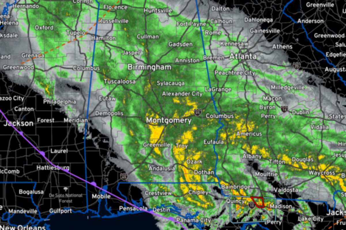
Widespread Rain Across Alabama: Widespread rain continues to blanket Alabama as a weather system dominated by a stalled front, upper-level low, and surface low maintains its hold over the region. This persistent precipitation has resulted in notable temperature variations across the state, with contrasting conditions experienced in different regions.
Meanwhile, a tornado warning has been issued for the Florida Panhandle, highlighting the alertness required due to associated weather conditions. Central Alabama is also under wind advisories, raising potential challenges throughout the day.
The evolving weather conditions, we will explore the diminishing rain and the intricate interplay of atmospheric components.
Key Takeaways
- Stalled front, upper-level low, and surface low are contributing factors to the widespread rain in Alabama.
- Southwestern regions of Alabama are experiencing less rainfall compared to other areas.
- Temperature variations across different regions of Alabama, with unique climate conditions in Birmingham and contrasting temperatures in Mobile.
- The interplay of atmospheric components, such as the stalled front, upper-level low, and surface low, influences the movement and intensity of rain in Central Alabama.
Weather System: Stalled Front, Upper-Level Low, and Surface Low Impact Alabama
The weather system impacting Alabama is characterized by a stalled front, an upper-level low, and a surface low. These three elements play a crucial role in the widespread rain across the state.
A stalled front occurs when two air masses with different characteristics meet but fail to move. In this case, it’s causing a prolonged period of precipitation.
The upper-level low refers to a pocket of cold air aloft, which enhances instability and supports the development of showers and thunderstorms.
Lastly, the surface low refers to a low-pressure area near the Earth’s surface, which helps in the convergence of moist air and triggers the formation of precipitation.
These three components working together are responsible for the ongoing rainfall across much of Alabama, with southwestern regions being an exception.
Temperature Variations Across the State: Notable Contrasts in Different Regions
In examining the temperature variations across Alabama, it becomes evident that notable contrasts exist in different regions of the state.
In North and North Central Alabama, temperatures are predominantly in the 40s, with specific areas like Scottsboro in Jackson County recording a temperature of 50F.
Birmingham and Mobile, on the other hand, display divergent climate conditions. To illustrate these differences, consider the following:
- North and North Central Alabama: Prevailing temperatures in the 40s, with Scottsboro in Jackson County reaching 50F.
- Birmingham: Experiencing its own unique climate conditions, distinct from the northern regions.
- Mobile: Showcasing yet another contrast in temperature, differing from both the northern and central areas.
Overall, Alabama exhibits significant temperature variations across its different regions, creating distinct climate patterns throughout the state.
These variations in temperature paint a vivid picture of the diverse weather conditions experienced across Alabama.
Tornado Warning in the Florida Panhandle: NWS Alert and Associated Weather Conditions
A tornado warning has been issued by the National Weather Service (NWS) for parts of Jefferson and Leon Counties in the Florida Panhandle. This warning is a result of the vigorous surface low in the region, which has prompted the NWS to issue alerts for possible tornado formation. The low-pressure readings in the area are indicative of the unstable atmospheric conditions that can contribute to tornado development.
Wind gusts at Tyndall Air Force Base have reached up to 55 mph, while Tallahassee has experienced gusts up to 46 mph. Jacksonville has also observed gusts up to 41 mph. These strong winds, combined with the unstable conditions, pose a significant threat and residents are urged to take necessary precautions to ensure their safety.
| Location | Low Pressure (inches) | Wind Gusts (mph) |
|---|---|---|
| Tyndall Air Force Base | 29.51 | 55 |
| Tallahassee | 29.57 | 46 |
| Jacksonville | 29.69 | 41 |
Wind Advisories for Central Alabama: Potential Challenges Throughout the Day
With wind advisories in effect, Central Alabama is facing potential challenges throughout the day due to the expected strong wind conditions. These conditions may lead to various difficulties, including:
- Trees and power lines being knocked down, causing power outages and potentially hazardous situations.
- Loose objects, such as trash cans and outdoor furniture, being blown around, posing a risk to property and personal safety.
- Driving becoming hazardous, with reduced visibility and the possibility of vehicles being pushed off course by strong gusts.
- Construction sites and outdoor work being affected, as high winds can make it difficult to safely carry out tasks and may result in damage to structures.
It is crucial for residents and businesses in Central Alabama to stay informed about the wind advisories and take necessary precautions to minimize potential risks during this period of challenging wind conditions.
Evolving Weather Conditions: Rain Diminishing, Atmospheric Components at Play
Continuing to analyze the evolving weather conditions in Central Alabama, the focus now shifts to the diminishing rainfall and the intricate interplay of atmospheric components.
The latest forecast indicates a decrease in rain from the south as the evening progresses. This diminishing rain is a result of various atmospheric factors working together. The stalled front, upper-level low, and surface low are all contributing to the dynamic weather conditions observed across the state.
These components interact in complex ways, influencing the movement and intensity of the rain. Understanding this interplay is crucial for accurately predicting and monitoring the weather conditions in Central Alabama.
As the rain diminishes, it will be important to closely monitor these atmospheric components to anticipate any further changes in the weather.
Conclusion Of Widespread Rain Across Alabama
Alabama is experiencing widespread rain due to a stalled front, upper-level low, and surface low. The state is also seeing temperature variations across different regions and a tornado warning in the Florida Panhandle.
Central Alabama is under wind advisories, posing potential challenges throughout the day. As the weather evolves, the rain is expected to diminish with various atmospheric components at play.
ALSO READ: ADEM Innovative Road Project for St. Clair County
Our Reader’s Queries
How do I turn on weather alerts?
Activate Weather alerts on your Android 12 device by swiping up from the bottom of the home screen to open the app drawer. Find the Weather app and long-press the icon. Then, tap the App info button from the options that appear. Next, go to Notifications and simply slide the Weather alert button to the on position to enable weather alerts.
How do I turn on weather alerts on Android?
Navigate to the “Settings” app on your Android device. Tap on “Notifications” and then select “Advanced Settings.” From there, choose “Wireless emergency alerts” and switch on the “Allow Alerts” option. Make sure to turn on all the alert options listed below to ensure you receive important notifications.
What is the weather alert app for Android?
The Storm Shield app delivers severe weather alerts to users based on their exact location. It uses voice alerts, like a NOAA weather radio, through push notifications. The app also provides access to radar maps, current conditions, and hourly and daily forecasts. It includes nationwide radar, NWS forecasts, and severe weather alerts to keep you informed and safe.