Strong Winds Expected Across Alabama: A potent storm system approaching Alabama is expected to bring strong winds across the state, posing potential disruptions and challenges for various regions.
Coastal areas are particularly bracing for high winds, while southern Alabama faces the added threat of severe storms and tornadoes.
In the northern and north-central parts of the state, strong winds, storms, and significant rainfall are anticipated.
Understanding the nature of gradient winds and implementing necessary preparedness measures are imperative as Alabama prepares for the impact of this weather system.
Key Takeaways
- National Weather Service issued warnings for tree limb damage and power outages
- Potential risk extends beyond usual severe storm-prone areas
- Residents advised to take necessary precautions
- Emergency plans should include securing loose outdoor items and having essential supplies
Anticipation of Potent Weather System Bringing Winds to Alabama
The anticipation of a potent weather system bringing strong winds to Alabama has prompted the National Weather Service to issue warnings for potential tree limb damage and power outages across the state, with a particular focus on north and central Alabama. The NWS is closely monitoring the approaching storm, which is expected to arrive on Monday afternoon and persist into Tuesday morning. This weather system has the potential to bring winds that extend beyond the usual severe storm-prone areas, posing a significant risk to the entire state.
Residents and communities in Alabama are advised to take necessary precautions to protect themselves and their property from the potential impacts of this powerful storm. Strong winds can cause tree limbs to break and fall, leading to property damage and posing a threat to public safety. Power outages are also a concern, as the high winds can cause power lines to be damaged or knocked down. It is essential for individuals to have emergency plans in place, including securing loose items outdoors and having a supply of essential items such as batteries, flashlights, and non-perishable food.
The National Weather Service is actively monitoring the storm’s progression and providing updates and warnings as necessary. They are working closely with local authorities and emergency management agencies to ensure that the public is well-informed and prepared for the potential impacts. It is crucial for residents to stay updated on the latest weather forecasts and advisories and to follow any instructions or recommendations given by local officials.
- Potent weather system with strong winds
- Expected arrival on Monday afternoon
- Potential for tree limb damage and power outages
- Focus on north and central Alabama
- Early warnings allow residents to take necessary precautions
- Collaboration between National Weather Service and local authorities ensures effective communication
- Continuous monitoring and updates provide real-time information
- Potential for property damage and power outages
- Disruption to daily activities and potential safety hazards
- Possible delays or cancellations of outdoor events or travel plans.
READ MORE: Alabama Braces for Weekend Storms: Strong Winds, Possible Tornadoes in the Forecast
Coastal Regions Bracing for High Winds and Potential Disruptions
Coastal regions in Alabama are preparing for high winds and potential disruptions as a potent storm system approaches. The coastal areas, particularly Mobile and Baldwin counties, are currently under a high wind warning, with winds expected to exceed 60 mph. This poses significant risks, including the possibility of downed trees and power outages. The entire state is under wind advisories, emphasizing the need for caution and preparedness. To highlight the potential impact of this storm system, let’s take a look at the following table:
| Potential Disruptions | Coastal Regions |
|---|---|
| Downed Trees | Mobile County |
| Power Outages | Baldwin County |
| Property Damage | Coastal Areas |
| Transportation Delays | Entire State |
This table underscores the importance of taking necessary precautions and staying informed about the evolving weather conditions. Coastal communities in Alabama must remain vigilant and be prepared for potential disruptions caused by the approaching storm system.
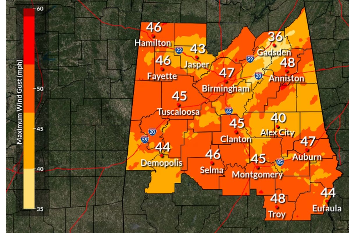
Southern Alabama Faces Dual Threat of Severe Storms and Tornadoes
Southern Alabama is experiencing a dual threat of severe storms and tornadoes. As a result, residents in these areas are urged to exercise caution and stay informed about the rapidly changing weather conditions.
The Storm Prediction Center has designated a Level 3 out of 5 severe weather risk, highlighting the potential for widespread wind damage, including gusts exceeding 70 mph. The following are key points to consider:
- Vigilance: It is crucial for residents to remain vigilant and stay updated on the latest weather warnings and advisories.
- Preparedness: Take proactive measures to ensure personal safety, such as securing loose objects outdoors, stocking up on essential supplies, and having an emergency plan in place.
- Shelter: Identify safe locations in your home or community where you can seek shelter in the event of a tornado warning.
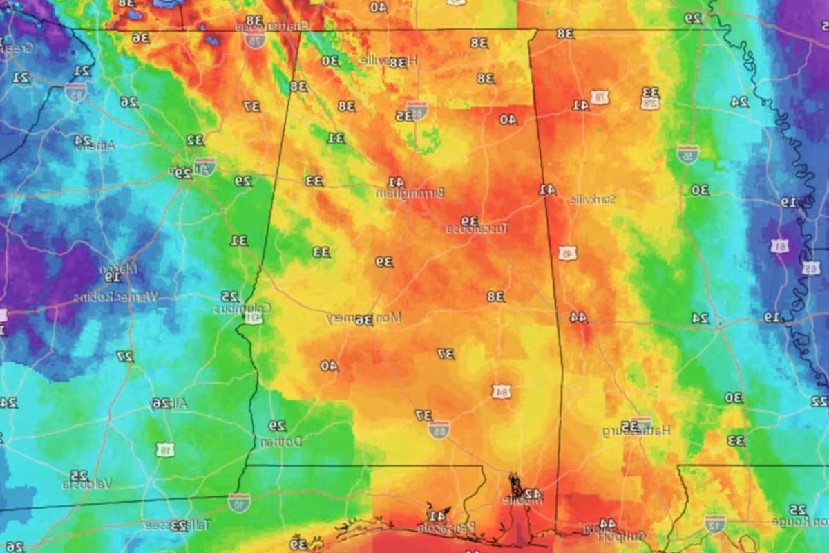
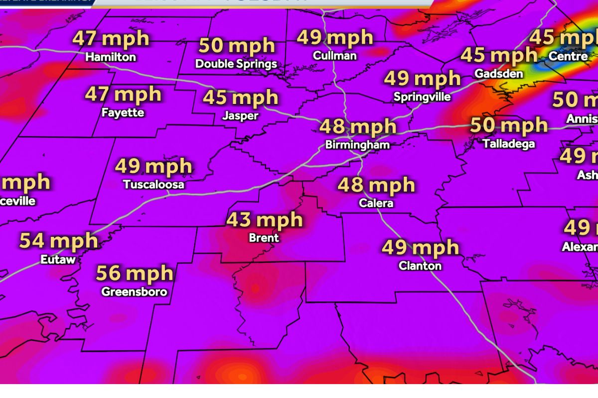
Impacts on North and North-Central Alabama: High Winds, Storms, and Rainfall
As the potent storm system continues to move across Alabama, the impacts on north and north-central regions will include high winds, storms, and heavy rainfall. While severe storms are not expected, these areas remain vulnerable to the effects of the storm.
The National Weather Service (NWS) forecasts rain spreading from west to east, with northern and central areas experiencing gradient winds. These non-thunderstorm winds can reach potential gusts of up to 45 mph or higher, especially in elevated terrain.
It is important to note that the combination of high winds and heavy rainfall can lead to hazardous conditions, such as falling trees and power outages. Residents in these regions should stay updated on weather alerts and take necessary precautions to ensure their safety.
Understanding Gradient Winds and Preparedness Measures
Residents should understand the concept of gradient winds and take appropriate preparedness measures in the face of the strong winds expected across Alabama due to the potent storm system. Gradient winds are the result of the pressure difference between a low-pressure area and a high-pressure area. As the pressure gradient increases, the wind speed also increases.
To ensure safety during these strong winds, residents should:
- Secure loose objects: Strong winds can easily pick up and throw objects, causing damage or injury. Secure loose items such as patio furniture, garbage cans, and outdoor decorations.
- Stay indoors: Seek shelter inside a sturdy building and avoid going outside unless absolutely necessary. Falling debris or flying objects can pose a significant danger during high winds.
- Be cautious near the coast: Coastal areas are particularly susceptible to stronger winds. If you live near the coast, stay informed about any potential coastal flooding or gale conditions and follow the instructions of local authorities.
Conclusion Of Strong Winds Expected Across Alabama
Alabama is expected to experience strong winds as a potent storm system approaches.
Coastal regions are preparing for high winds and potential disruptions, while southern Alabama faces the additional threat of severe storms and tornadoes.
In the north and north-central areas of the state, high winds, storms, and rainfall are anticipated.
It is important for residents to understand gradient winds and take necessary preparedness measures to ensure their safety during this weather event.
Also Read: Alabama Basketball First SEC Win
Our Reader’s Queries
What direction does the wind blow in Alabama?
During the summer, the main winds blow from the southwest, while in winter, they come from the northwest.
What is the coldest month in Alabama?
January typically brings the coldest temperatures, but from mid-December to mid-February, there isn’t a significant difference. Generally, winters are fairly mild, and even during cold snaps, it’s uncommon for the temperature to stay below freezing all day.
How does El Niño affect Alabama?
In the central and southern parts of the state, winters are wetter than usual, while in the northern part they are drier (Figure 4a). During winter, El Niño brings the most rain in the central and southern regions, while La Niña is the wettest in the north.
What storm has strong winds?
A Derecho is a severe and destructive thunderstorm that lasts a long time. It gets classified as a derecho if the swath of wind damage is over 240 miles long and the wind gusts reach at least 58 mph along most of the storm’s path.