Possible Strong Storms Loom Over Alabama: Alabama residents should prepare for potential strong storms tonight with tornado watches in effect. Severe weather warnings have been issued, especially for southwest and south-central areas. Tornado threats remain high, with the risk of damaging winds, small hail, and possible tornadoes. Stay updated on weather alerts as the situation evolves.
Counties like Barbour, Pike, and others are under the tornado watch until 2 a.m. It’s important to have multiple sources for weather updates and a safety plan in place. Be vigilant and heed advice from local authorities to guarantee safety during this severe weather event.
Tornado Threat and Warnings in Alabama
Amidst the imminent threat of strong storms in Alabama tonight, the state remains under a tornado watch with several warnings issued in different counties.
As of 11:10 p.m., a tornado warning has been issued for southern Coosa County until midnight, indicating a severe thunderstorm capable of producing a tornado over Mitchell Lake.
Fortunately, the tornado warning for Chilton County was canceled at 11:17 p.m., although reports of multiple trees down on County Road 424 have been received.
The National Weather Service has determined that the severe weather threat has diminished for north Alabama but cautions about the continued potential for strong to severe storms in central and south Alabama.
It is vital for residents in these areas to remain vigilant and stay updated on the latest weather advisories to ensure their safety.
The authorities are closely monitoring the situation and providing timely updates to help the community prepare and respond effectively to the ongoing weather challenges.
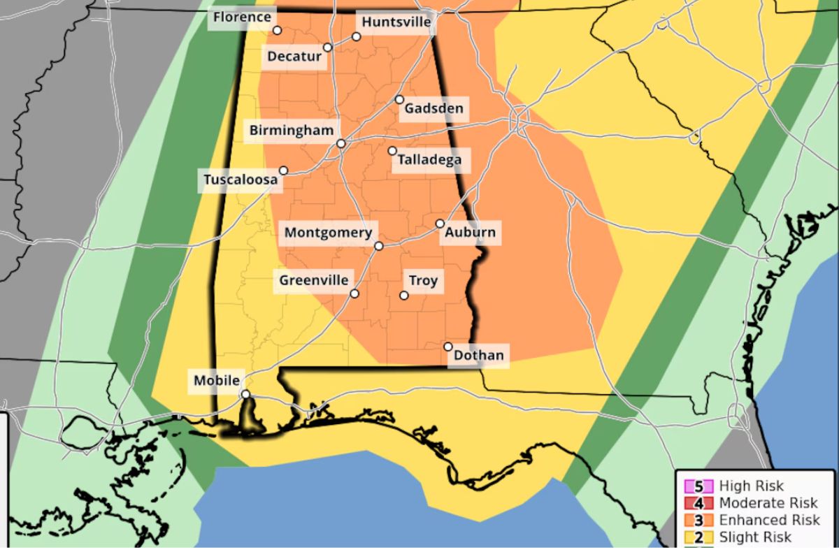
Severe Weather Risk and Outlook
The current severe weather risk and outlook in Alabama highlight the potential for scattered to numerous severe storms overnight, with NOAA’s Storm Prediction Center maintaining a Level 3 risk for a significant portion of the state. This Level 3 risk signifies a likelihood of severe weather, including damaging winds, small hail, and the possibility of tornadoes, particularly across southwest Alabama and far interior south-central Alabama.
In contrast, the rest of the state faces a Level 2 risk, where scattered severe storms are possible. However, the weather service office in Mobile has adjusted the risk locally to marginal for areas near the coast due to evolving forecast trends indicating a reduced threat. Despite this adjustment, residents in the mentioned regions should remain vigilant and prepared for changing weather conditions.
It is essential to stay updated on weather alerts and have a safety plan in place to protect life and property from the potential impact of severe storms.
Ongoing Tornado Watch and Counties Affected
As the ongoing tornado watch approaches its expiration at 2 a.m., numerous counties in Alabama, including Barbour, Pike, Russell, Bullock, Lee, Macon, Autauga, Bibb, and Calhoun, remain under its alert. These areas are currently at risk of experiencing severe weather conditions that could potentially lead to tornado formation. It is important for residents in these counties to stay vigilant and prepared as the night progresses.
While some counties have been removed from the watch, such as DeKalb, Blount, Hale, and Jefferson, among others, the threat of severe storms still looms over the region. The dynamic nature of severe weather systems necessitates continued monitoring and readiness.
Residents are advised to have multiple reliable sources for receiving weather alerts, especially during the overnight hours when tornadoes can be particularly dangerous. Staying informed and having a plan in place can significantly enhance safety during these potentially hazardous conditions.
Outlook for Clearing Conditions and Beyond
After the impending departure of the storm system, a shift towards cooler and drier conditions is expected to prevail in Alabama for the remainder of the week. As the storm clears out on Wednesday, residents can anticipate a reprieve from the turbulent weather that has characterized the region in recent days.
The cooler temperatures will bring relief from the oppressive heat, providing a more comfortable atmosphere for outdoor activities and daily routines. Additionally, the drier conditions will aid in drying out any lingering moisture, reducing the risk of flooding or water-related issues.
It is vital for residents to remain vigilant despite the improving weather conditions, as the aftermath of severe storms can present its own set of challenges. It is advisable to stay informed about any updates or advisories from local authorities to guarantee continued safety and preparedness. By staying alert and proactive, residents can navigate the shift to clearer weather with confidence and peace of mind.
News in Brief
The imminent danger of powerful storms in Alabama tonight has triggered tornado alerts and an increased risk of severe weather. Residents in impacted counties should stay watchful and stay informed of the ongoing tornado watch.
Clearing conditions may be anticipated in the near future, but the possibility of hazardous weather remains a concern. Stay updated on the most recent developments and take essential precautions to guarantee safety.
ALSO READ: Potent Storm System Targets Alabama