'Alabama's Diverse Landscapes: A Geographical Marvel' offers an insightful exploration of the intricate topography that defines the state of Alabama. This comprehensive study delves into the geological intricacies that have sculpted Alabama's diverse terrains, showcasing a rich tapestry of natural wonders.
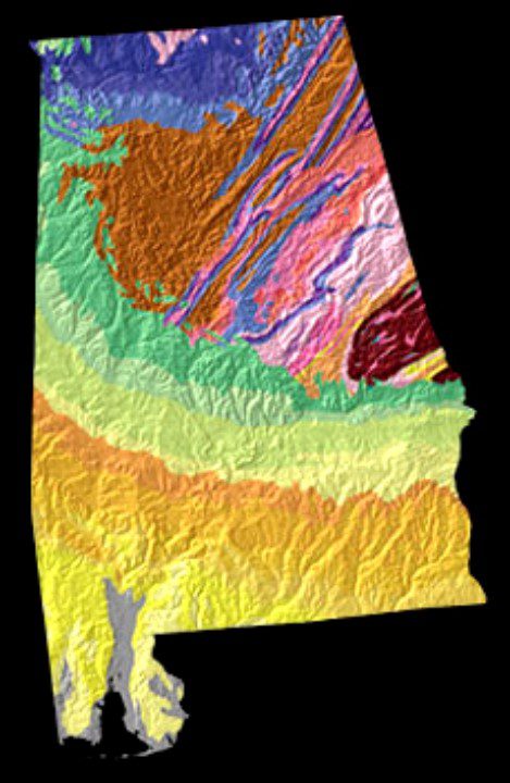
From the Appalachian Highlands Region, with its distinct physiographic provinces and sections, to the Interior Plains Region and the Atlantic Plain Region, each area reveals unique relief features and geological formations.
This article presents an in-depth examination of Alabama's varied landscapes, highlighting their geological significance and captivating beauty. It provides a compelling narrative for those seeking mastery in understanding the complex interplay of physiographic processes and the resulting marvels of Alabama's geographical diversity.
Key Takeaways
- Alabama has five physiographic sections, three in the Appalachian Highlands Region.
- The Valley and Ridge Province in Alabama is divided into seven districts.
- Alabama has one physiographic section in the Interior Plains Region.
- Alabama has one physiographic section in the Atlantic Plain Region.
Alabama's Physiographic Regions
Alabama's physiographic regions showcase a diverse array of landscapes shaped by complex geological processes. The state's geological history has played a significant role in shaping its biodiversity.
The Appalachian Highlands Region, for instance, is characterized by the Piedmont Province, Valley and Ridge Province, and the Appalachian Plateaus Province. These regions have diverse topographies, including plateaus, ridges, and valleys, which have had a profound impact on the state's biodiversity.
The Interior Plains Region, with its low plateaus and distinct Highland Rim Section, also contributes to the varied landscapes and habitats within Alabama.
Furthermore, the Atlantic Plain Region, specifically the East Gulf Coastal Plain Section, exhibits rounded hills and floodplains, further enriching the state's ecological diversity.
Appalachian Highlands: A Closer Look
Exploring the Appalachian Highlands region reveals a diverse array of landscapes shaped by geological processes, contributing to Alabama's rich biodiversity. The area's geological formations and rock types have resulted in unique landforms and ecosystems. The following table provides a brief overview of the geological formations and rock types found in the Appalachian Highlands region:
| Geological Formations | Rock Types |
|---|---|
| Appalachian Plateaus | Sandstone, shale |
| Valley and Ridge Province | Limestone, dolomite, sandstone |
| Piedmont Plateau | Metamorphic rocks, granite |
These formations have played a crucial role in shaping the region's topography and have provided habitats for a wide variety of flora and fauna. Understanding the geological diversity of the Appalachian Highlands is essential for appreciating the complexity of Alabama's natural landscapes.
Valley and Ridge Province
The Valley and Ridge Province in Alabama comprises a series of zigzagging ridges and deep valleys, forming a distinctive and diverse landscape within the Appalachian Highlands Region.
- Formation Processes:
- Folded and faulted sedimentary rock layers shaped by tectonic forces.
- Thrust faulting leading to the uplift of ridges and the creation of valleys.
- Erosion sculpting the landscape, exposing layers of rock and creating stunning geological formations.
The geological features of this province include long, parallel ridges with narrow valleys between them, showcasing a stunning array of rock types, colors, and textures. This province's unique topography and geological history make it a captivating area for geological enthusiasts and nature lovers alike.
Appalachian Plateaus: Unique Features
The Appalachian Plateaus in Alabama exhibit unique geological features arising from tectonic forces and erosion, contributing to the region's diverse and captivating landscapes.
These plateaus are characterized by extensive flat-topped areas, deeply entrenched valleys, and geological formations such as sandstone, shale, and limestone.
The plateaus boast abundant natural resources, including coal, natural gas, and timber, which have historically played a vital role in the region's economic development.
Additionally, the rugged terrain and scenic beauty of the Appalachian Plateaus make it an attractive area for outdoor recreation and tourism.
The interplay of geological formations and natural resources in this region underscores its significance within Alabama's diverse landscapes, offering a rich tapestry of both natural beauty and economic opportunity.
Interior Low Plateaus Province
Nestled within Alabama's diverse landscapes, the Interior Low Plateaus Province showcases distinct geological features shaped by tectonic forces and erosion. This region is characterized by the Highland Rim Formation, which gives rise to unique landforms.
The Interior Low Plateaus Province features:
- Two east-west valleys and a low ridge in the Highland Rim Section.
- Valleys formed in easily eroded limestone, while the ridge developed on more resistant sandstone.
- Varied relief features resulting from the interplay of weathering, erosion, and deposition processes.
This province's intricate landscapes offer a captivating insight into the geological history of Alabama, making it a must-see for those interested in the earth's dynamic processes.
Highland Rim Section
Situated within the Interior Low Plateaus Province of Alabama, the Highland Rim Section showcases distinctive geological formations. The Highland Rim formation is characterized by two east-west valleys and a low ridge. Valleys in this section formed in easily eroded limestone, while the ridge developed on more resistant sandstone. The geologic history of the Highland Rim dates back to millions of years, shaped by processes such as weathering, erosion, and deposition. This unique section provides a glimpse into the intricate physiographic processes that have sculpted Alabama's diverse landscapes.
| Geological Formation | Description |
|---|---|
| East-West Valleys | Formed in easily eroded limestone |
| Low Ridge | Developed on resistant sandstone |
| Physiographic Processes | Weathering, erosion, deposition |
Coastal Plain Province
Within the Coastal Plain Province of Alabama, a diverse array of landscapes unfolds, showcasing a wide variety of geological features and formations.
This region is characterized by its unique wetland ecosystems, which play a crucial role in supporting a rich and diverse array of plant and animal species.
Additionally, the Coastal Plain Province is home to stunning barrier islands that serve as natural buffers against the forces of the ocean and provide important habitats for various wildlife.
These barrier islands also offer breathtaking views and opportunities for outdoor recreational activities, making them an integral part of the region's natural beauty.
Alabama's Coastal Plain Province truly stands out for its remarkable wetlands and barrier islands, adding to the geographical marvel of the state.
East Gulf Coastal Plain Section
The East Gulf Coastal Plain Section of Alabama's Coastal Plain Province exhibits a diverse array of geological formations and features, contributing to the region's unique and captivating landscape. This section's unique topography is a result of various formation processes, including the deposition of eroded materials by rivers and the gradual shaping of the land over time.
The region is characterized by rounded hills and expansive floodplains, a testament to the dynamic interplay of erosion and deposition processes. The presence of these features creates a visually striking landscape that offers a glimpse into the geological history of the area.
Additionally, the East Gulf Coastal Plain Section is not a flat, featureless plain, but rather a mosaic of landforms that adds to the overall richness and diversity of Alabama's Coastal Plain Province.
Alabama's Diverse Landscapes in Summary
Alabama's diverse landscapes exhibit a captivating blend of geological formations and features, showcasing the intricate interplay of physiographic processes that have shaped the region's unique topography.
These diverse landscapes are a result of the impact of physiographic processes, including weathering, erosion, and deposition, which have sculpted the land over millions of years.
The classification of landscapes into physiographic regions, provinces, sections, and districts further emphasizes the complexity and richness of Alabama's topography.
From the zigzagging ridges and deep valleys of the Valley and Ridge Province to the relatively flat uplands of the Appalachian Plateaus Province, each region offers a distinct and awe-inspiring landscape.
Alabama's geological formations and the dynamic forces of nature have collaboratively created a geographical marvel that continues to captivate and inspire.
Frequently Asked Questions
How Do Physiographic Processes Like Weathering and Erosion Impact Alabama's Landscapes?
Physiographic processes like weathering and erosion have shaped Alabama's diverse landscapes, impacting geological formations. Erosion has formed distinct relief features, while weathering has contributed to the creation of varied landforms across the state.
What Are the Specific Geological Features That Make up the Valley and Ridge Province in Alabama?
The Valley and Ridge Province in Alabama exhibits distinct geological features, shaped by physiographic processes. Its varied topography, including zigzagging ridges and deep valleys, reflects the impact of weathering, erosion, and deposition, contributing to the Appalachian plateaus formation.
How Did the Appalachian Plateaus in Alabama Form and What Unique Features Can Be Found There?
The Appalachian Plateaus in Alabama formed through tectonic forces and erosion, resulting in unique features like steep cliffs, deep canyons, and waterfalls. These formations, representing a geographical marvel, showcase the region's diverse and captivating landscape.
What Are the Distinctive Characteristics of the Highland Rim Section in the Interior Low Plateaus Province?
The Highland Rim Section in Alabama's Interior Low Plateaus Province exhibits distinctive features, including karst topography characterized by sinkholes, caves, and disappearing streams. These unique landforms result from the dissolution of easily eroded limestone.
What Are Some Examples of the Diverse Landscapes Found Within Alabama's Coastal Plain Province?
The diverse landscapes found within Alabama's Coastal Plain Province display a range of geological formations shaped by various physiographic processes. Examples include rounded hills and floodplains in the East Gulf Coastal Plain Section, showcasing a diverse terrain shaped by natural forces.
Conclusion
In conclusion, Alabama's diverse landscapes are a testament to the intricate and awe-inspiring forces of nature.
From the rugged peaks of the Appalachian Highlands to the gentle slopes of the Coastal Plain, the state's topography offers a captivating display of geological wonders.
Each physiographic region and province tells a unique story of weathering, erosion, and deposition, creating a rich tapestry of natural beauty.
Alabama's landscapes are a geographical marvel that continues to inspire and enthrall all who behold them.
Our Reader’s Queries
What are the main physiographic provinces of Alabama?
Alabama boasts an expansive terrain that encompasses the Coastal Plain, Piedmont, Ridge and Valley, Appalachian Plateau, and Interior Plateau. These vast regions extend beyond the state borders, showcasing the diverse landscape and natural beauty.
What are the 5 geographic regions of Alabama?
Alabama is home to six unique ecoregions: the Southern Coastal Plain, Southeastern Plains, Piedmont, Ridge and Valley, Southwesterrn Appalachians, and Interior Plateau. Each region has its own distinct characteristics and ecosystems, making Alabama a diverse and fascinating place for nature enthusiasts.
What are the 7 regions in Alabama?
The Tennessee River valley is located in the Highland Rim in the northwest, while the Cumberland Plateau in the northeast is known for its flat-topped plateaus. To the southeast is the Appalachian Ridge and Valley, which includes the Coosa River and the iron-rich Red Mountain.
Check Out For More References