Monitoring a Critical Storm in Montgomery: As dark clouds loom over Montgomery County, a critical storm is brewing, prompting heightened monitoring by local authorities. With a thunderstorm alert issued and the possibility of tornadic activity on the horizon, residents are urged to stay vigilant and prepared.
The projected path of the storm and its potential impact on various areas within the county are of utmost concern. Stay tuned for crucial updates on the evolving situation and essential safety measures to be taken in light of the impending severe weather conditions.
Key Takeaways
- Significant tornado potential in Pike Road, Cecil, Mitchell, and Hardaway areas.
- Urgent need to stay indoors and secure outdoor items.
- Residents in the storm’s path advised to monitor updates closely.
- NWS warning for Bullock, Montgomery, and Macon Counties until 4:15 PM CST.
Thunderstorm Alert in Montgomery Area
A significant thunderstorm alert has been issued for the Montgomery area as a powerful storm system sweeps through southwestern Montgomery County, impacting regions along US 31 and I-65. This alert signifies the potential for severe weather conditions, including strong winds, heavy rainfall, and lightning strikes.
Residents are advised to stay indoors and away from windows, as well as to secure any outdoor furniture or objects that could be blown away by the high winds associated with this storm. It is crucial to monitor local weather updates and heed any further warnings issued by authorities.
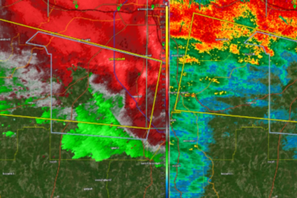
Tornado Potential in Montgomery County
What indicators suggest the potential for tornado development in Montgomery County as the storm progresses east-northeast along the southern side of I-85?
The storm currently displays signs of rotation just west of Sprague and south of Snowdoun, with high reflectivity and broad rotation, which are key factors indicating the potential for tornado formation.
As the storm continues its path, areas such as Pike Road, Cecil, Mitchell, and Hardaway are of immediate concern. It is crucial to monitor these regions closely as the storm evolves, staying vigilant as it remains positioned just south of I-85.
Residents in these areas should stay informed and be prepared to take necessary precautions in the event that a tornado does develop.
Projected Path and Impacted Areas
As the storm progresses, its projected path will impact areas including Pike Road, Cecil, Mitchell, and Hardaway in Montgomery County before moving into Macon County. Residents in these regions should closely monitor updates and heed any warnings issued by local authorities to ensure their safety.
The potential impact of the storm on these areas necessitates preparedness measures to mitigate risks associated with severe weather conditions. Understanding the projected path of the storm allows residents to anticipate its trajectory and take necessary precautions.
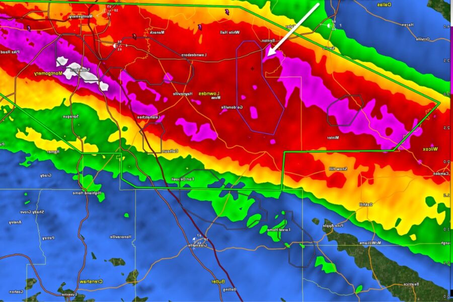
National Weather Service Warning Issued
The recent National Weather Service warning issued for parts of Bullock, Montgomery, and Macon Counties highlights the imminent threat posed by severe thunderstorms in specific regions. The warning, effective until 4:15 PM CST, specifically addresses northwestern Bullock County, southwestern Macon County, and central Montgomery County. Here are some key points to keep in mind:
- Severe Thunderstorm Warning: Issued by NWS in Birmingham.
- Affected Counties: Bullock, Montgomery, and Macon Counties.
- Timeframe: Effective until 4:15 PM CST.
- Specific Areas: Northwestern Bullock County, southwestern Macon County, and central Montgomery County.
Stay tuned for further updates and adhere to safety guidelines to ensure preparedness and protection during this critical weather event.
ALSO READ: Alabama Parents Rally for Change Push for Expanded Newborn Screening
Severe Thunderstorm Impact and Safety Measures
In the wake of the severe thunderstorm currently impacting Montgomery County and surrounding areas, prioritizing safety measures is paramount to mitigate potential risks and ensure the well-being of residents.
The storm over Sprague presents dangers of 60 mph wind gusts, capable of causing damage to roofs, siding, and trees. Regions under warning, including Union Springs, Meadville, Pike Road, and Pine Level, are particularly at risk.
Residents must act swiftly, remaining vigilant and seeking shelter until the storm subsides. Taking proactive safety measures is crucial during such severe weather events to prevent harm and protect lives.
Stay tuned to official updates and adhere to safety guidelines to navigate through this challenging weather episode safely.
Conclusion Of Monitoring a Critical Storm in Montgomery
Residents of Montgomery County should remain vigilant and prepared for the potential impact of the critical storm.
Following safety measures and heeding warnings from the National Weather Service is essential to ensuring the well-being of individuals in the affected areas.
Stay informed and take necessary precautions to protect yourself and your community from the severe thunderstorm.