Drier Weather Ahead for Alabama: As the rain clouds dissipate and the sun starts to peek through, Alabamians can finally breathe a sigh of relief as drier weather is forecasted for the week ahead.
After a period of heavy rainfall that brought some much-needed relief to the ongoing drought conditions in central Alabama, the weather outlook shows a shift towards a drier pattern.
While the recent rain has been beneficial, it’s important to delve deeper into the implications of this drier weather and its potential consequences.
Will this dry spell continue? How will it impact the already saturated soil? These questions and more will be explored as we analyze the upcoming weather trends and their possible implications for Alabama.
Key Takeaways
- Central Alabama received substantial rainfall, bringing relief to drought conditions.
- Water levels in lakes and reservoirs have risen, alleviating concerns of water scarcity.
- The recent rainfall has improved air quality and provided cooler temperatures.
- The weather outlook for the week predicts drier conditions, allowing for outdoor activities and brighter days.
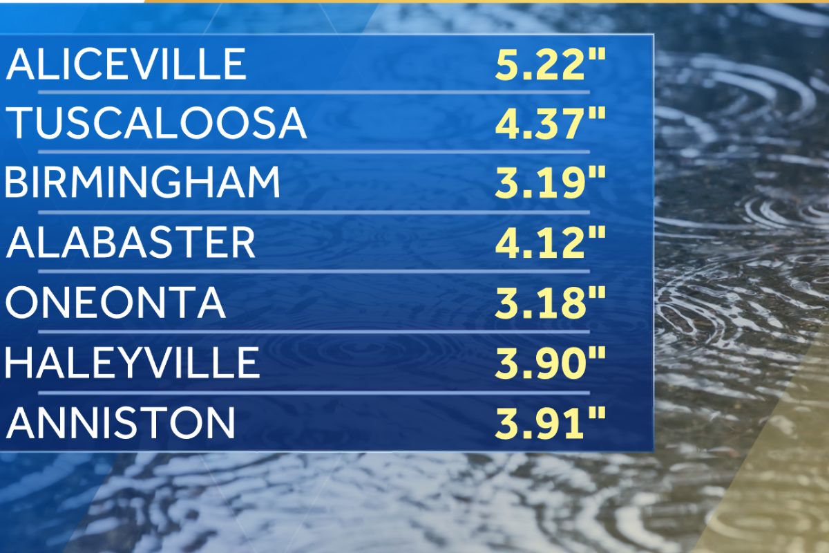
Rainfall Brings Relief to Central Alabama’s Ongoing Drought
After weeks of persistent drought, Central Alabama received a much-needed reprieve as substantial rainfall brought relief to the region. Accumulating an average of three to five inches, this precipitation has proven to be beneficial for the area.
The rainfall has helped replenish the parched soil, providing a welcome boost to farmers and agricultural activities. Additionally, the water levels in lakes and reservoirs have risen, alleviating concerns of water scarcity and potential water restrictions.
The rain has also improved air quality by reducing the amount of dust and pollutants in the atmosphere. Moreover, the cooler temperatures that accompanied the rainfall have provided some respite from the sweltering heat that has plagued the region.
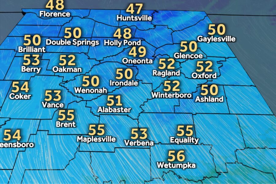
Weather Outlook for the New Week: Chilly Start with Brighter Skies
Following the much-needed rainfall that brought relief to Central Alabama’s ongoing drought, the weather outlook for the new week promises a chilly start with brighter skies ahead. Here are the details:
- Chilly Temperatures: On Monday morning, residents can expect temperatures in the 30s, requiring heavy coats for warmth. However, the presence of clouds will prevent temperatures from dropping below freezing.
- Cloud Dissipation: As the day progresses, the clouds are expected to dissipate, allowing for brighter skies in the afternoon. This will bring a welcome change from the gloomy weather of the previous days.
- Above Freezing: Despite the chill, temperatures will remain slightly above freezing. In the upper 40s and low 50s, the weather will be slightly below the late January average but still manageable.
- Relief from Rain: With drier weather on the horizon, Alabama can enjoy a break from the recent rainfall, allowing for outdoor activities and brighter days ahead.
Unusual Temperature Trends in Central Alabama: A Closer Look
Central Alabama has been experiencing unusual temperature trends that deviate significantly from the average for this time of year. Typically, the month of January sees high temperatures in the 50s and lows in the middle 30s. However, only six days this month have recorded temperatures within two degrees of this average.
It is quite remarkable to note the wide temperature range experienced in Central Alabama during January. On January 16, the temperature plummeted to a staggering 22 degrees below the average, while on January 25, it soared to an astonishing 21 degrees above the average.
These unusual temperature swings have left residents puzzled and uncertain about what to expect next. The drastic deviation from the normal temperature patterns in Central Alabama this month has certainly caught the attention of weather enthusiasts and experts alike.
ALSO READ: Flash Flood Watch Issued Across North/Central Alabama
Cold Front Approaching: Changes Expected Midweek
The upcoming week in Central Alabama will bring changes as a cold front approaches, bringing with it cooler temperatures and the possibility of light rain late Tuesday night.
Here are four key points to keep in mind regarding this cold front:
- Timing: The cold front is expected to move in on Tuesday night into early Wednesday. This means that we can expect a shift in weather patterns as January concludes and February begins on Thursday.
- Cooler Temperatures: As the cold front sweeps through the region, it will bring a drop in temperatures. This means that we should prepare for cooler weather in the days following the front’s arrival.
- Possibility of Light Rain: Along with the cooler temperatures, there is a chance of light rain accompanying the front late Tuesday night. While it may not be significant precipitation, it is something to be aware of.
- Reinforcing the Cool Weather: The arrival of this cold front will reinforce the cool weather that we have been experiencing. So, if you have been enjoying the cooler temperatures, this front will help to maintain those conditions.
Groundhog Day Forecast and Potential Winter Extension
With the arrival of Groundhog Day on February 2nd approaching, Alabama residents eagerly await the forecast as it may provide insights into a potential extension of the winter season. Currently, the Groundhog Day forecast for Alabama indicates sunny and cool conditions. This scenario would suggest a prediction of a shadow and, according to folklore, six more weeks of winter. To provide a clearer picture, let’s take a look at the potential winter extension in the table below:
| Date | Forecast |
|---|---|
| February 2nd | Sunny and cool |
| February 10+ | Cold and wintry |
If the Groundhog Day prediction holds true, longer-range forecasts align with the potential for another cold and possibly wintry pattern around or after February 10. Alabama residents should prepare for the possibility of enduring a prolonged winter season. Stay tuned for updates and keep warm!
Conclusion Of Drier Weather Ahead for Alabama
In conclusion, Alabama can expect drier weather this week, bringing some relief to the ongoing drought in Central Alabama. The weather outlook for the new week indicates a chilly start with brighter skies ahead.
Unusual temperature trends have been observed in Central Alabama, warranting a closer look. Additionally, a cold front is approaching and changes are expected midweek. As we approach Groundhog Day, the forecast suggests a potential extension of winter.
Our Reader’s Queries
How do I turn on weather alerts?
Activate Weather alerts on your Android 12 device by swiping up from the bottom of the home screen to open the app drawer. Find the Weather app and long-press the icon. Then, tap the App info button from the options that appear. Next, go to Notifications and simply slide the Weather alert button to the on position to enable weather alerts.
Can Google home give weather alerts?
Easily check the weather and upcoming forecast for your area using just your voice with a Google Nest or Home speaker or display.
How do I turn on weather alerts on Android?
Navigate to the “Settings” app on your Android device. Tap on “Notifications” and then select “Advanced Settings.” From there, choose “Wireless emergency alerts” and switch on the “Allow Alerts” option. Make sure to turn on all the alert options listed below to ensure you receive important notifications.
What is the weather alert app for Android?
The Storm Shield app delivers severe weather alerts to users based on their exact location. It uses voice alerts, like a NOAA weather radio, through push notifications. The app also provides access to radar maps, current conditions, and hourly and daily forecasts. It includes nationwide radar, NWS forecasts, and severe weather alerts to keep you informed and safe.