Alabama Weather Dry and Warm Conditions: As Alabamians have been enjoying a stretch of dry and warm weather, a shift is on the horizon. The tranquil skies and mild temperatures that have characterized recent days are poised to transform as a significant weather system approaches the region.
With the arrival of a midweek cold front, residents can anticipate a notable change in the familiar weather patterns. This transition not only brings a shift in temperatures but also holds the potential for impactful weather events.
Stay tuned to discover how these upcoming changes may influence the landscape and daily routines across the state.
Current Weather Conditions
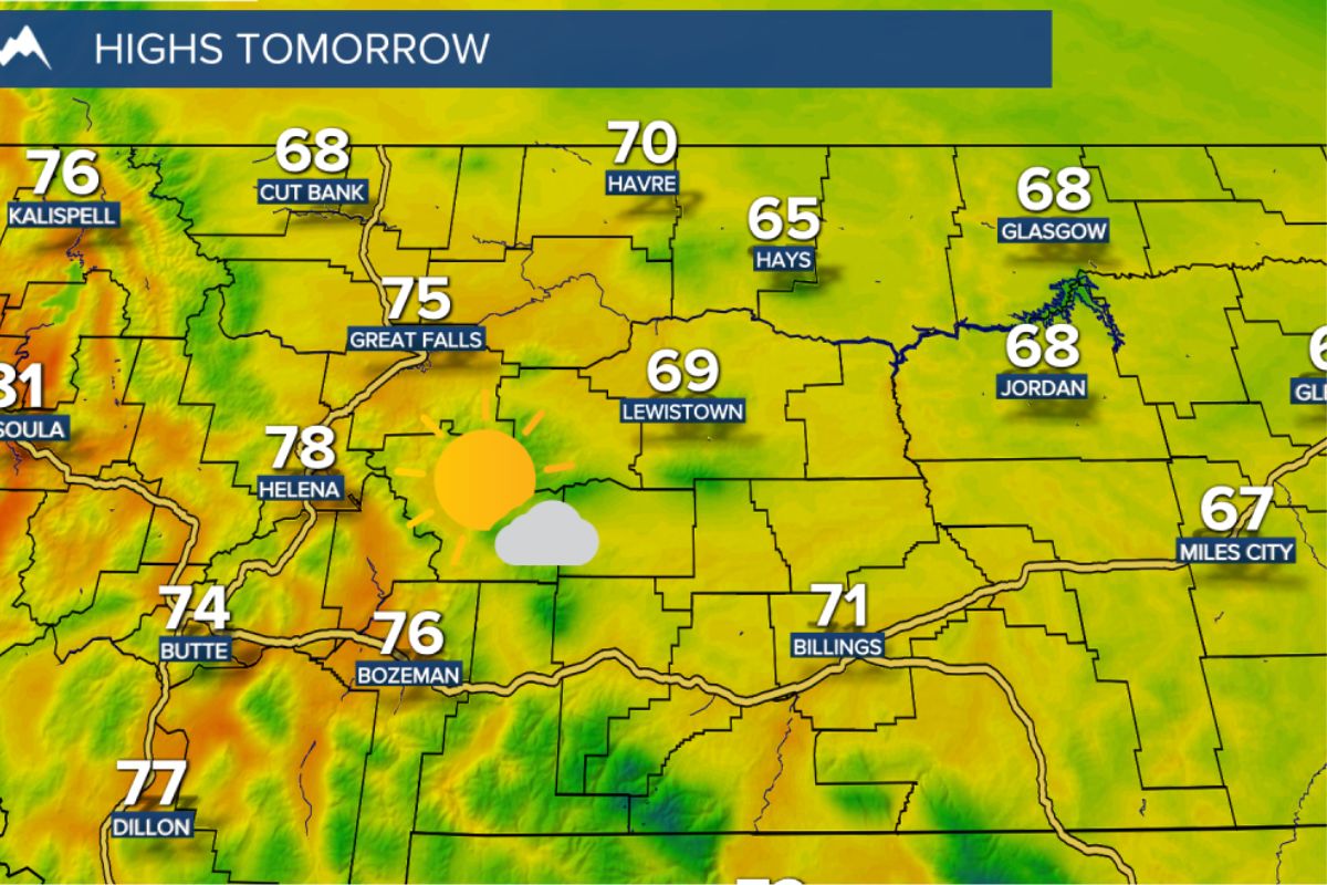
Basking under clear skies and unseasonably warm temperatures, Alabama currently enjoys dry weather conditions with temperatures in the 70s, notably exceeding the typical highs for this period in Birmingham. The state is experiencing a pleasant spell, with the afternoon forecast promising a continuation of these conditions. However, there is a slight shift expected tomorrow morning as a few scattered showers may appear over the northern third of Alabama. Despite this, the afternoon is anticipated to bring some sunshine, making it the warmest day of the year so far. High temperatures are projected to range from 75 to 82 degrees, providing residents with a taste of early summer weather.
This uncharacteristically warm weather has brought a sense of joy to many Alabamians, who are relishing the opportunity to spend time outdoors without the need for heavy layers. The skies have been a brilliant blue, and the gentle breeze adds to the overall pleasantness of the current weather conditions. Alabama’s landscape is painted with vibrant colors as flowers bloom under the bright sun, creating a picturesque setting for all to enjoy.
Midweek Cold Front
As Wednesday approaches, a significant change in Alabama’s weather pattern is on the horizon as a cold front is set to sweep through the state. This cold front will bring a band of showers and the chance of isolated thunderstorms, although severe storms are not expected.
What sets this weather event apart is the stark temperature contrast it will create across Alabama. Northern regions are forecasted to experience temperatures dropping into the 40s, a noticeable shift from the recent warmth. In contrast, southern areas will maintain milder conditions, with highs reaching the 70s. Central counties can anticipate a midday peak near 70 degrees before temperatures gradually decline throughout the afternoon.
This abrupt transition in temperatures highlights the dynamic nature of Alabama’s weather patterns and underscores the need for residents to stay informed and prepared for these fluctuations.
ALSO READ: Alabama Disaster Relief Training Strengthen Volunteer Force
Extended Forecast and Historical Weather Events
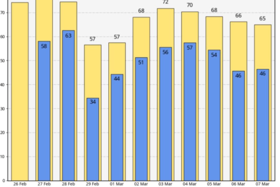
The extended forecast for Alabama includes a cooling trend with dry conditions on Thursday followed by the return of rain on Friday. As the weekend approaches, mostly cloudy skies are expected with scattered showers and a slight increase in temperatures. Moving into the following week, Monday may bring scattered showers, while the potential for storms looms later in the week ahead of an approaching cold front.
Reflecting on historical weather events on this date, significant incidents stand out. The Buffalo Creek disaster of 1972 left a mark in history when a coal slag dam failure led to extensive damage and tragic loss of life. Additionally, in 2008, a derecho swept through parts of Central Alabama during the early morning hours, bringing with it thunderstorm wind gusts and tornadoes.
These past events serve as reminders of the unpredictable nature of weather and the importance of staying informed and prepared for any potential weather-related challenges that may arise.
News in Brief
Alabama experiences an unusual stretch of warm, dry weather, with temperatures exceeding norms. The current conditions delight residents, providing an early taste of summer, characterized by clear skies and highs in the 70s. However, a midweek cold front promises significant changes. While tomorrow morning may see scattered showers in the northern part of the state, the afternoon remains warm and sunny. This transition introduces a remarkable temperature contrast, with northern areas dropping into the 40s while southern regions maintain milder conditions in the 70s. Residents are urged to stay informed as the dynamic weather pattern unfolds. The extended forecast indicates a cooling trend, dry conditions, and the return of rain, emphasizing the need for preparedness. Historical weather events on this date, such as the Buffalo Creek disaster in 1972 and a derecho in 2008, underscore the unpredictable nature of weather.