Rain Returns Sunday Dry Through Friday: As we head into the weekend, it seems that Mother Nature has a mixed bag of weather in store for us.
After a few days of dry and pleasant conditions, the forecast suggests that rain will make its return on Sunday. However, before we jump ahead to the weekend, let’s take a closer look at what we can expect in the days leading up to it.
With cooler temperatures following a recent clipper system, the gradual increase in temperature will bring statewide highs reaching the 60s and low 70s.
But what about the rain on Sunday? Will it be just a passing shower or a prolonged wet spell? Stay tuned as we explore the extended outlook and some historical weather events that have occurred on this date in the past.
Key Takeaways
- Cooler temperatures are expected after a clipper system, providing a refreshing break from recent warmth.
- The current outlook is for mostly sunny skies and dry conditions through Friday.
- There will be a gradual increase in temperatures, with statewide highs reaching the 60s and low 70s.
- Rain is likely to enter western counties after midnight on Saturday night, leading to a cooler and more damp atmosphere with highs in the 50s on Sunday.
Current Weather Conditions and Outlook: Cooler Temperatures Follow Clipper System
Following the passage of a clipper system, cooler temperatures are expected to prevail in the coming days, according to the current weather conditions and outlook.
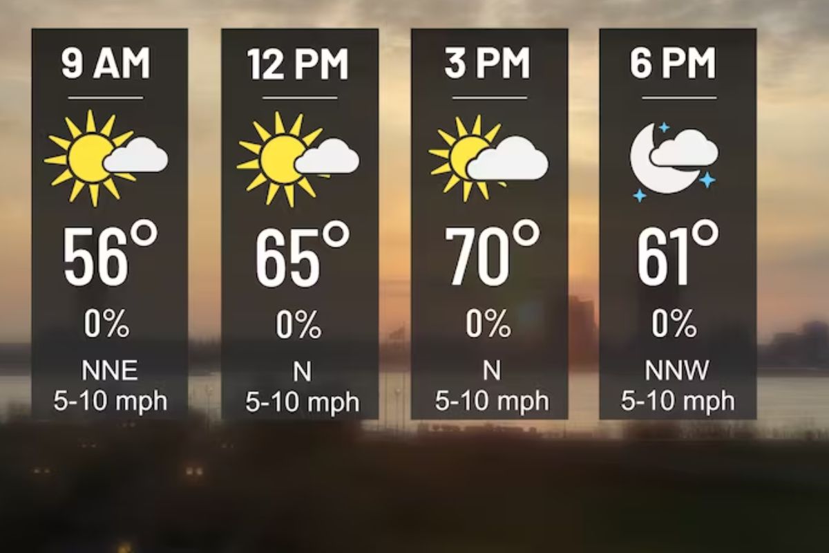
The weather outlook for Alabama indicates a shift to cooler temperatures as the clipper system moves away. Today, the state can expect mostly sunny skies with highs in the 50s.
This trend of cooler weather will continue through Friday, with dry conditions and fair nights. The clipper system brought light rain to the region last night, but now Alabama can anticipate a break from precipitation.
This change in weather conditions offers a refreshing respite from the recent warmth and a chance for residents to enjoy the cooler temperatures and clear skies.
Temperature Forecast: Gradual Increase with Statewide Highs Reaching 60s and Low 70s
The temperature forecast for the upcoming days indicates a gradual increase, with statewide highs expected to reach the 60s and even low 70s in certain areas of Southern Alabama.
Tomorrow’s high is anticipated to be in the 55-65 degree range, with temperatures reaching the 60s across the state on Friday. However, some areas in Southern Alabama may experience even warmer temperatures, reaching the low 70s on Friday afternoon.
This gradual increase in temperatures is a welcome change after the cooler temperatures following the recent clipper system.
As we head into the weekend, residents can look forward to milder weather and the opportunity to enjoy outdoor activities in the pleasant 60s and low 70s.
Weekend Forecast: Dry and Pleasant Saturday, Rain Likely on Sunday
As temperatures continue to rise across Alabama, the weekend forecast brings a dry and pleasant Saturday followed by the possibility of rain on Sunday.
On Saturday, we can expect highs ranging from 63 to 73 across the state, creating ideal conditions for outdoor activities. However, clouds will start to increase later in the day, signaling the approaching change in weather.
By Saturday night, rain is likely to enter the western counties after midnight, setting the stage for a wet Sunday. While some thunder is possible in South Alabama, severe storms are not expected.
Sunday’s highs will generally be in the 50s, providing a cooler and more damp atmosphere compared to the previous day.
ALSO READ: Drier Weather Ahead for Alabama This Week Across
Extended Outlook: Lingering Light Rain, Dry Conditions, and Historical Weather Events
In the extended outlook, a chance of lingering light rain is expected for Monday as an upper low moves through, followed by a dry period from Tuesday through Thursday with highs ranging from the 50s to the 60s.
This upper low is likely to bring scattered showers, but nothing too heavy or prolonged. Starting from Tuesday, the weather is expected to improve, with dry conditions prevailing for the rest of the week. Temperatures will remain mild, with highs ranging from the 50s to the 60s, creating pleasant conditions for outdoor activities.
Towards the end of the week, on Friday, there is a possibility of some light rain, but no extreme cold Arctic air is foreseen for the Deep South in the next 7-10 days. Overall, the extended outlook suggests a mostly dry and comfortable week ahead.
Historical Weather Events on This Date: Ice Storm in 1951 and Record-Breaking Cold in 1989
Historical weather events on this date include a devastating ice storm in 1951 and a record-breaking cold snap in 1989. These events left a lasting impact on the affected regions and serve as reminders of the power and unpredictability of nature.
The ice storm in 1951 was particularly destructive, causing widespread damage from Louisiana to West Virginia and earning the title of the costliest ice storm on record.
In 1989, Norway, Alaska experienced an all-time record for the North American Continent with a barometric pressure of 31.85 inches at a bone-chilling temperature of about 46 degrees below zero. Additionally, severe arctic cold invaded the north-central U.S., resulting in significant temperature drops and extreme wind chill readings in Montana.
These historical weather events serve as significant milestones in our understanding of weather patterns and their potential impacts.
Conclusion Of Rain Returns Sunday Dry Through Friday
The weather forecast predicts:
- Cooler temperatures
- Gradual increase in temperatures
- Dry and pleasant Saturday
However, rain is expected on Sunday.
The extended outlook indicates:
- Lingering light rain
- Followed by dry conditions
Additionally, historical weather events on this date include:
- An ice storm in 1951
- Record-breaking cold in 1989.
Our Reader’s Queries
How do I turn on weather alerts?
Activate Weather alerts on your Android 12 device by swiping up from the bottom of the home screen to open the app drawer. Find the Weather app and long-press the icon. Then, tap the App info button from the options that appear. Next, go to Notifications and simply slide the Weather alert button to the on position to enable weather alerts.
Can Google home give weather alerts?
Easily check the weather and upcoming forecast for your area using just your voice with a Google Nest or Home speaker or display.
How do I turn on weather alerts on Android?
Navigate to the “Settings” app on your Android device. Tap on “Notifications” and then select “Advanced Settings.” From there, choose “Wireless emergency alerts” and switch on the “Allow Alerts” option. Make sure to turn on all the alert options listed below to ensure you receive important notifications.
What is the weather alert app for Android?
The Storm Shield app delivers severe weather alerts to users based on their exact location. It uses voice alerts, like a NOAA weather radio, through push notifications. The app also provides access to radar maps, current conditions, and hourly and daily forecasts. It includes nationwide radar, NWS forecasts, and severe weather alerts to keep you informed and safe.