Severe Storms Possible Tomorrow: we address the potential severe storms looming for tomorrow, as well as the anticipated upcoming arctic freeze set to hit next week.
This comprehensive report aims to provide a detailed analysis of the current conditions, including a pleasant winter day in Alabama, as well as an enhanced risk of severe storms, their timing, and associated hazards.
Additionally, we offer insights into the weekend forecast, highlighting dry and colder conditions, followed by the coldest air of the season expected with the forthcoming arctic blast.
Stay informed and prepared with our expert analysis.
Key Takeaways
- Severe storms are expected tomorrow in Alabama, with an enhanced risk of damaging winds, large hail, tornadoes, heavy rain, and flash flooding.
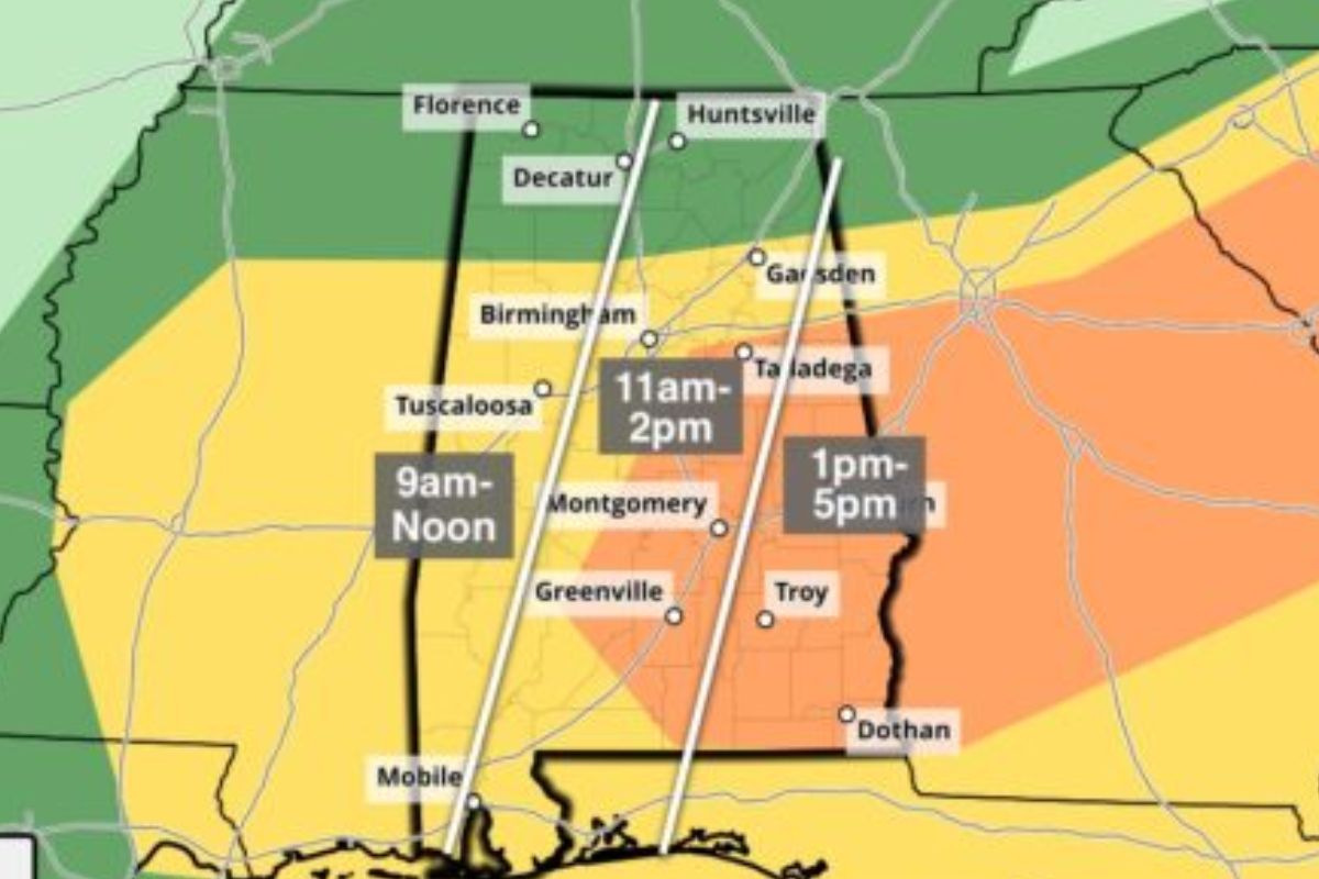
- The severe storms will occur from 9:00 a.m. to 4-5 p.m., and the enhanced risk area could experience a strong tornado of EF-2 or higher intensity.
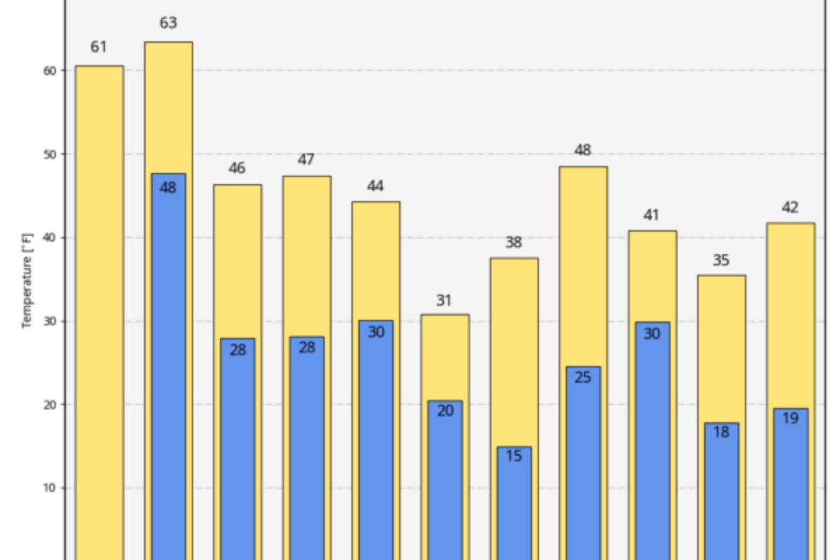
- The weekend forecast calls for dry and colder conditions, with morning lows ranging from 23-32 degrees and highs in the 40s and 50s.
- Alabama is bracing for an Arctic blast next week, with the coldest temperatures of the season expected and potential wintry precipitation over the northern half of the state. Residents are advised to stay weather-aware and take necessary precautions.
Current Conditions: A Pleasant Winter Day in Alabama
With dry and pleasant conditions in Alabama today, the state is experiencing a pleasurable winter day. The skies are partly to mostly sunny, allowing for plenty of sunshine to warm up the region. Temperatures are expected to reach a comfortable range of 60-65 degrees, providing a break from the colder temperatures typically associated with winter.
This weather pattern is a result of a high-pressure system currently in place, which is suppressing any moisture and creating stable atmospheric conditions. However, it is important to note that clouds are expected to move in tonight as a precursor to an approaching storm system.
Therefore, while today offers a reprieve from the cold, it is advisable to stay updated on the weather forecast to prepare for potential changes in the days ahead.
READ MORE: First Alert Weather Day: Bracing for Severe Weather Threats in Alabama
Severe Storms Tomorrow: Enhanced Risk Issued by SPC
Are severe storms expected tomorrow with an enhanced risk, according to the Storm Prediction Center (SPC)?
The SPC has issued an ‘enhanced risk’ of severe thunderstorms for parts of East, Central, and Southeast Alabama.
Here are four reasons why this should be concerning:
- Damaging winds: The storms could produce strong winds that can cause extensive damage to structures and trees.
- Large hail: The potential for large hail increases the risk of property damage and poses a threat to anyone caught outside.
- Tornadoes: The atmospheric conditions are favorable for the development of tornadoes, which can be extremely destructive and life-threatening.
- Heavy rain and flash flooding: The storms may bring heavy rainfall, leading to flash flooding in low-lying areas and potentially causing road closures and property damage.
It is crucial for residents in the affected areas to stay informed and take necessary precautions to ensure their safety.
Severe Storms Timing and Hazards
The severe storms anticipated tomorrow will bring with them a number of hazards, including strong, damaging straight-line winds, large hail, and the potential for tornadoes. These storms are expected to occur during the daytime, starting around 9:00 a.m. and lasting until 4-5 p.m.
The enhanced risk area could experience a strong tornado of EF-2 or higher intensity. Straight-line winds can cause significant damage, with gusts reaching up to 70 mph or more. Large hail, measuring 1 inch or more in diameter, can cause damage to vehicles, buildings, and crops.
The potential for tornadoes adds an additional level of danger, as these rotating columns of air can cause widespread destruction. It is important to stay informed about the weather conditions and take appropriate safety measures to protect yourself and your property.
Weekend Forecast: Dry and Colder Conditions Ahead
Dry and colder conditions are expected over the weekend following the severe storms. Morning lows will range from 23-32 degrees, with highs in the 40s over North Alabama and 50s for the southern counties on Saturday and Sunday.
As we prepare for the transition to colder weather, here are some key points to keep in mind:
- Layer up: Dress in warm layers to stay comfortable and protected from the cold.
- Stay hydrated: Even in colder temperatures, it’s important to drink plenty of water to stay hydrated.
- Mind the wind chill: Pay attention to the wind chill factor, as it can make the air feel even colder than the actual temperature.
- Protect your skin: Remember to apply moisturizer and wear sunscreen, as cold weather can still be harsh on the skin.
Take these precautions and enjoy the weekend with confidence, knowing that you are prepared for the dry and colder conditions ahead.
Arctic Blast Next Week: Coldest Air of the Season Expected
Following the transition to colder weather over the weekend, Alabama is bracing for an Arctic blast next week, which will bring the coldest air of the season. The forecast indicates that early next week, the state will experience the coldest temperatures yet, with potential wintry precipitation over the northern half of Alabama on Monday night into Tuesday morning.
Throughout the week, cold temperatures will persist, with most areas of the state staying below freezing all day on Tuesday. By Wednesday morning, lows will drop into the 10-15 degree range over the northern half of the state.
Residents are advised to stay weather-aware and take necessary precautions to prepare for the impending severe weather and the subsequent Arctic blast. Historical weather events on this date, such as the 1918 snowstorm and tornado and the 2021 accumulating snow, serve as reminders of the varied weather challenges Alabama may face.
Stay updated with the latest information through the provided video briefing.
Conclusion Of Severe Storms Possible Tomorrow
Residents in Alabama can expect pleasant winter conditions today, followed by the possibility of severe storms tomorrow, as indicated by the issuance of an enhanced risk by the SPC.
The timing and hazards of these storms are yet to be determined. However, the weekend forecast predicts dry and colder conditions ahead.
Furthermore, an arctic blast is anticipated next week, bringing the coldest air of the season.
Stay informed and prepared for potential weather fluctuations in the coming days.
Our Reader’s Queries
How do I turn on weather alerts?
Activate Weather alerts on your Android 12 device by swiping up from the bottom of the home screen to open the app drawer. Find the Weather app and long-press the icon. Then, tap the App info button from the options that appear. Next, go to Notifications and simply slide the Weather alert button to the on position to enable weather alerts.
How do I turn on weather alerts on Android?
Navigate to the “Settings” app on your Android device. Tap on “Notifications” and then select “Advanced Settings.” From there, choose “Wireless emergency alerts” and switch on the “Allow Alerts” option. Make sure to turn on all the alert options listed below to ensure you receive important notifications.
What is the weather alert app for Android?
The Storm Shield app delivers severe weather alerts to users based on their exact location. It uses voice alerts, like a NOAA weather radio, through push notifications. The app also provides access to radar maps, current conditions, and hourly and daily forecasts. It includes nationwide radar, NWS forecasts, and severe weather alerts to keep you informed and safe.