Alabama Braces for Severe Storms Today: As Alabama is on alert for severe storms today, it is important for residents to stay tuned to the latest updates and advisories. With the possibility of damaging winds, hail, and heavy rainfall looming, understanding the timeline and potential impact of these storms is essential.
The evolving weather conditions present challenges that require preparedness and vigilance, especially as the prime window for severe weather approaches in the evening. Stay informed on safety measures and keep a close eye on the forecasts to navigate through this period of heightened weather activity.
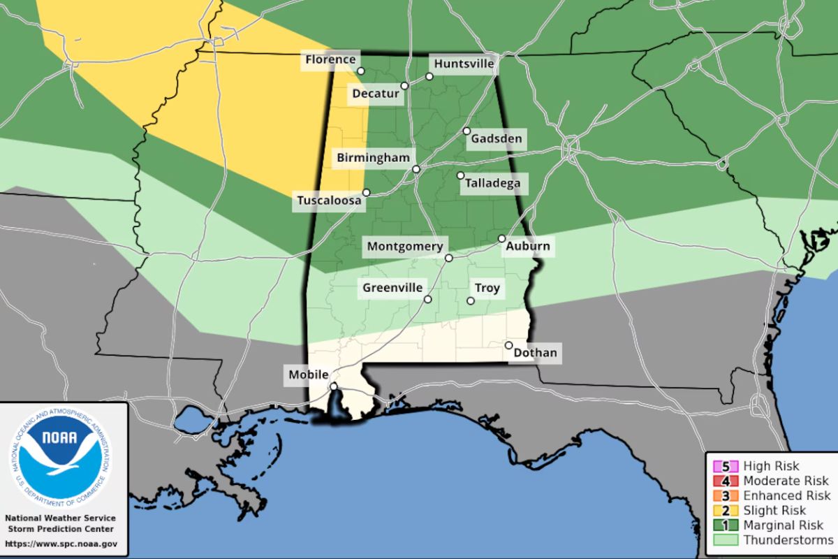
Severe Thunderstorm Watch Issued for Central Alabama
As Alabama braces for severe storms today, a Severe Thunderstorm Watch has been issued for Central Alabama by NOAA’s Storm Prediction Center. This watch, effective until 1 a.m. Monday, encompasses a significant portion of central Alabama, including areas where the risk of severe weather is heightened.
The National Weather Service cautions residents about potential hazards such as wind gusts reaching up to 60 mph, hail, and heavy rainfall that may accompany stronger storms forming in the region. The prime window for storm activity is projected to be during the evening and nighttime as a cold front advances southward into the state.
Severe Weather Outlook and Continued Risk
The forecast for Alabama indicates that the risk for severe weather will persist into Monday morning, particularly in south Alabama where a Level 1 risk is anticipated by the Storm Prediction Center. Following Monday, drier weather is expected to settle in starting on Tuesday, with a decrease in humidity through at least Wednesday, as reported by the weather service. Fortunately, after Monday, the rest of the week shows no severe weather in the forecast for Alabama.
This Level 1 risk signifies isolated severe storms could occur, with the primary threats being damaging wind gusts and potentially large hail. It is important for residents in the affected areas to stay informed about weather updates and to take necessary precautions to safeguard their safety.
As the severe weather outlook continues, it is vital to remain vigilant and prepared for any potential developments. Stay tuned to official weather sources for the latest updates and be ready to act swiftly in response to any severe weather warnings.
Weather Forecast
An urgent thunderstorm watch issued for central Alabama highlights the importance of hazardous weather conditions in the region, with residents advised to stay alert and monitor updates for wind gusts up to 60 mph, hail, and heavy rain.
The NOAA’s Storm Prediction Center emphasizes the necessity for vigilance as these severe weather elements pose risks to the area.
While the immediate concern extends into Monday morning for south Alabama, there is hope on the horizon as the forecast predicts drier conditions starting Tuesday. This shift offers a glimpse of relief from the turbulent weather pattern that has gripped the region.
It is essential for residents to remain informed and prepared as weather conditions evolve throughout the week. By staying abreast of updates and following safety guidelines, individuals can navigate through this period of heightened weather activity with caution and readiness.
Stay tuned to reliable sources for the latest information and take necessary precautions to ensure personal safety and well-being.
News in Brief
Residents of Alabama should remain vigilant and prepared for the ongoing severe weather conditions, including the potential for damaging wind gusts, hail, and heavy rainfall. Stay updated on the latest weather forecasts and warnings, and take necessary precautions to guarantee safety.
It is crucial to stay informed and be proactive in response to the evolving weather situation. Stay safe and be prepared for any potential impacts from the severe storms.
ALSO READ: EPA Shuts Down Alabama Power Coal Ash Plan What’s Next?